Monday, July 31, 2006

Passionfruit

Nantucket Nectars' "Orange Mango" juice is actually a combination of orange, mango, and passionfruit. So why don't they call it "Orange Mango Passionfruit"? Do they think that people don't like passionfruit? Or is it just too long of a name?

Sunday, July 30, 2006

Cheesecake

In case you didn't know, today is Cheesecake Day.

In the immortal words of my sister's best-friend's cousin's a cappella group's rendition of the song, "Freeze Frame":

Cheesecake cheesecake
.
.
.


Happy Cheesecake Day! Yum!

Build the Elliott Bay Bridge

A persistent issue here in Seattle is the question of what to do with the Alaskan Way Viaduct. The double-decker roadway, which runs along the waterfront beside downtown, is in danger of collapse if we have a strong enough earthquake. This is a life-and-death issue, so of course the Seattle politicians have spent the past few years proposing and discussing and attacking and not actually getting anything done. I wonder if they -- and Mayor Greg Nickels in particular -- would be happiest if the "ugly" thing just fell down. Then they wouldn't actually have to make a decision.

The politicians have managed to limit the discussion to a choice between completely rebuilding the viaduct and replacing it with a tunnel beneath its current location. The tunnel (which would be below sea level) is estimated to cost $4 billion by its supporters -- so you know it would actually cost more than that. The replacement option would cost $2 billion, supposedly.

A vocal group has been pushing for just tearing the old structure down and replacing it with nothing. All traffic, they say, would be absorbed by the surface streets. While this would undoubtedly cost the least of any option, in terms of upfront costs, it would be disastrous to Seattle's economy. Residents and businesses would escape the unceasing gridlock by relocating to other cities. Perhaps the supporters of this idea are from Tacoma or Portland. . .

Last week, I heard a different idea: build a bridge over Elliott Bay. The proposed idea would be to build a cable-stayed bridge that branches off from highway 99 just where the viaduct starts by the mouth of the Duwamish River and then proceeds just off-shore up the waterfront to rejoin the current highway at the entrance to the Battery Street tunnel. Since cable-stayed bridges have a typical span of a quarter-mile, numerous piers would have to be constructed along the route.

When I first heard the bridge idea, I didn't know the proposed route and automatically assumed a different route entirely. I figured that when you say you're building a bridge over Elliott Bay, you're not just building it along the shore, a hundred yards off the end of the piers. I envisioned a route from West Seattle, on the west side of the Duwamish industrial area, across the open water to dive straight into the Battery Street tunnel:


The flags along the line represent pier locations a half-mile apart. This would match the longest cable-stayed bridge in the world, as well as the span of the Tacoma Narrows Bridge, a rather modest (nowadays) suspension bridge just down the Sound a few miles. The water of Elliott Bay is indeed quite deep, which makes pier construction difficult (and costly), but the techniques used in constructing the new Tacoma Narrows Bridge caissons would work even easier in Elliott Bay, for the lack of strong tides. Those caissons -- the bases of the piers -- now sit in 140' of water. The deepest caisson in Elliot Bay would be in 240' of water. But, as I said, no strong tides to mess up construction.

The shoreline bridge would have caissons at a depth of 150', since the bay floor drops off so rapidly from the waterfront.

The new Tacoma Narrows Bridge currently under construction is to cost $850 million. Double the cost for doubling the piers from two to four, add for the deeper caissons, subtract for reduced overhead, and the cost of an Elliott Bay bridge is realistically in the neighborhood of $2 billion.

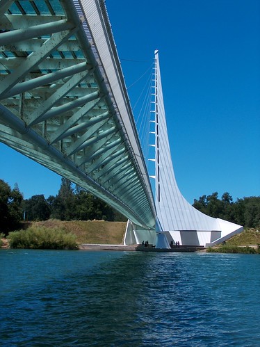
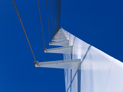
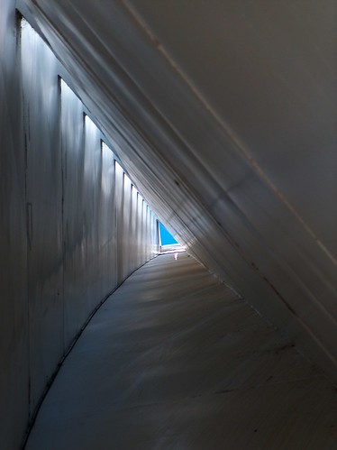
Yes, it would still be half the cost of Mayor Nickels's tunnel scheme and the same cost as the replacement, and it would be a darn sight prettier, if you ask me. Especially if you get a world-renowned bridge designer to design the thing. Say, Santiago Calatrava, perhaps? Unless he's too busy with bridges in Spain and Dallas and Israel. Okay, let's hold a design competition.

Aligning the bridge from the west side of the Duwamish industrial area instead of the east has several advantages. First, it eases pressure off the perennially clogged West Seattle Bridge. Second, it gives ships room to maneuver once they pass underneath it. Third, instead of towering over the waterfront, the bridge would be at a quite photographable distance. And yes, people would photograph it. It would be a tourist attraction along the lines of the Golden Gate Bridge and the Sydney Harbor Bridge. It would bring even more tourists to the Jet City. The bridge would not be a view-blocking eyesore, as some may decry. It would enhance the view of everyone living and working upon the shores of Elliott Bay.

Fourthly, not nearly so many properties would need to be destroyed since this route would enter and exit the bay at nearly right angles, thus not wiping out long stretches of waterfront as the shoreline route would. In fact, if the bridge were done properly, the number of buildings knocked down could be counted on one hand. The people who are really in trouble are those directly between the Battery Street tunnel entrance and the waterfront. They'd be in the way no matter what happens elsewhere. West Marginal Way would need to be widened into a full highway from the bridge approach down to where Highway 99 crosses the river and intersects with Highway 509, and this would undoubted cause some displacement, also.

The benefits of a bridge to a tunnel or replacement viaduct (besides the cost) are several, as well. The bridge could be built while the existing roadway remains in use. There would not be years of gridlock during construction, as in the politicians' plans. Once the bridge is completed, the viaduct would be torn down and could be replaced with a wider version of the existing Alaskan Way or whatever else it is that Mayor Nickels would do with the waterfront once he had the highway buried underneath. Passengers on the bridge would have marvelous views of the city, the water, and the mountains -- something tunnel travelers would sorely miss. And as I said before, the bridge could solve the problem of the West Seattle Bridge at the same time.

So, an Elliott Bay Bridge is on the cheaper end of proposed alternatives; it solves the problem of construction congestion; it adds to Seattle's world-class harbor flavor; it reunites the waterfront with downtown; it serves the industrial areas and provides another connection to West Seattle; and yet it will never get built because the politicians in this city are stubborn, incompetent idiots. Bummer.

Saturday, July 29, 2006

They'd better make that movie.

What percentage of the people who would pay to see a movie entitled The Restaurant at the End of the Universe would google said film before they knew it existed? 1%? 5%? 0.5%

What percentage of said people would click a link labeled "I'm Awake: The Restaurant at the End of the Universe Movie" if it were the fifth one down? 50%? 90%?

If I have had nearly a thousand people (presumably separate individuals) follow such linkages to my blog from Google since I first posted said post in February, at the rate of five or so a day, every day, does that mean there is a viable audience for such a film?

When are they going to start production??

Friday, July 28, 2006

Où est mon stylo rouge?

No really. Where'd it go?

Thursday, July 27, 2006

News Roundup

The American Bar Association has pulled out of sponsoring a surfing competition for lawyers during their convention in Honolulu because they are afraid of being sued. The organizers have liability insurance, but apparently the ABA knows that's not good enough to stop lawyers! Oh well. At least they're self-aware.

. . . . .

In Tasmania, a bar with beer-drinking pigs has become the target of "animal-rights" activists. Patrons can pay to give the pigs a drink. The bar waters down the beer so the pigs never get drunk (a shame!), and evidently the pigs really like it. On slow days, the bar owners have to give the pigs a drink, or else they'd mope around or something.

The activists say that it's animal cruelty (the RSPCA disagrees) because pigs don't drink beer naturally. But do humans drink alcohol "naturally"? No, we had to work at it and use our great brainpower to create a beverage that ... diminishes our brainpower.


Since we're always being told that pigs are quite smart and similar to humans, why shouldn't our porcine friends benefit from our alcoholic creation?

But I suppose the real question is this: Do beer-fed pigs taste any different?

Wednesday, July 26, 2006

Don't Stop

Don't stop
Eating all your food
Don't stop
Lunch will soon be here
Lunch will be here
Better than before
Breakfast is gone
Breakfast is gone

rocks in my teeth

The city (at least I assume it's the city -- I didn't ask for proof of identification) has laid gravel down over most of the residential streets in my neighborhood. That was last week. They haven't been back.

So now the entire neighborhood is covered in loose gravel. Well, the streets, anyway. Turn a corner and the car fishtails slightly. Or try to turn onto an arterial from a full stop and the front wheels are just spinning.

I suppose it's a good way to teach the locals how to drive in adverse conditions.

But I got gravel stuck in my tires so they go clickety-clack-clickety-clack as I drive down the road. I removed three rocks this morning, but that was just the top of the left tires. Clickety-clack, everyone turns their heads to see the clickety-clack car go by. I like to be anonymous in my beige sedan. The city is ruining everything.

Monday, July 24, 2006

Lesson Learned

When next thou dost dive onto thine office's conference table, make certain to raise thine elbows. Or mayhaps, thou couldst wear a long-sleeve shirt.

'Cuz friction burns hurt.

Question

Does cruise control work in reverse?

Saturday, July 22, 2006

Hot enough for ya?

Even the most temperate corners of the kingdom are having incredibly high temperatures. And you know why? It's because today is the Holy Day of Zhoro, the God of Heat!

So He's just doing His thing, nothing to worry about.

Except the metric system, of course.

When it gets really hot, the Fahrenheit thermometer shows 100°. When it gets really cold, the Fahrenheit thermometer shows 0°. But the Celsius thermometer shows 38° and -18°, respectively. How silly is that? Not nearly so useful for day-to-day applications.

Friday, July 21, 2006

Yet More Photos

I know, I know. I've been back for a week. So why am I still posting vacation photos? Well, it's just taken me this long to sort through them all. We'll just have to live with it.

Okay, so where was I? Oh yes. Yosemite.

12-02-YosemiteFallsBottom
Yosemite Falls, Yosemite National Park

This is where I turned around. You can see a bit of the handrail lower down in the bottom right:
12-05-YosemiteFallsStop
Yosemite Falls, Yosemite National Park

13-03-VikingsholmChimneys
Vikingsholm, Emerald Bay

13-09-TahoeCityGoose
Truckee River, Tahoe City

13-21-ChesterBidwellRoom
Bidwell Inn, Chester

14-01-WestSulphurCreek
West Sulphur Creek, Lassen Volcanic National Park

14-02-PilotPinnacle
Pilot Pinnacle, Lassen Volcanic National Park

14-07-SulphurWorksFumarole
Sulphur Works, Lassen Volcanic National Park

14-12-LassenPkManzanitaLake
Manzanita Lake, Lassen Volcanic National Park

14-17-SundialUnder
Sundial Bridge, Redding

14-19-SundialCables
Sundial Bridge, Redding

14-25-SundialInside
Sundial Bridge, Redding

15-03-CastleCragsCloseup
Castle Crags, Castle Crags State Park

16-01-Hillsboro
Hillsboro, Oregon

And the rest. . .

Thursday, July 20, 2006

So Let's Carve up California

Driving around the Golden State, I found myself oft asking, "Am I really still in California?" From rugged coasts to soaring skyscrapers, from dead-flat farmlands to snow-covered mountains, California is certainly one of the most diverse states in terms of geography.

But it's also diverse in terms of the "feel" of a region. Crescent City seemed like part of the Northwest. Mendocino to Monterey seemed like an endless string of B&Bs pierced by the swanky Bay Area. South of Big Sur, I felt the pull of Los Angeles (and desparately fought it). Go over the mountains down into the Central Valley and it's a whole other world (with lots of country and Christian radio stations). The east side of the Sierra Nevada had a similar ethos to the Central Valley. Tahoe was its own creature, with the B&Bs of the San Francisco coast thrown in with the pulse of the Nevada casinos across the border, all on top of the rural culture. And then back into the giant valley. Redding felt more like Barstow than Crescent City or San Francisco, despite the disparate distances involved.

So I propose four states: the far north (southern Jefferson), the Bay Area and coast, the Central Valley and Sierra Nevada, and southern California. In the early 1990s, a state legislator tried to get the state divided into two, and then three. He was trying to separate the northern portion (Chico (his hometown) and northward), but then cut off SoCal, too, to get more support. But that still left San Francisco in the same state as Fresno, and I just don't see that as a winning solution. There's a definite dividing line somewhere between San Jose and Modesto.

To find the exact borders, I'd suggest a (non-binding) vote where the voters can rank the areas they most associate with. It would probably be simplist to separate along county lines, but maybe some (San Bernadino County, for instance) really want to be split.

I wonder where San Luis Obispo would end up.

Urba Burba Durba Urba

urba burba durba urba
urba durba burba urba

urba burba durba urba
urba durba burba urba

urba burba durba urba
urba durba burba urba

urba burba durba urba
urba durba burba urba

urba burba durba urba
urba durba burba urba

Wednesday, July 19, 2006

How I spend my freetime

This evening, between laundry and dishes, I created the religious pantheon of the empire of Nyıkãgo, the land northeast of the kingdom of Naraka.

You see, it was important because I needed to create the profanity, "plague of Kínıtíní!" to go along with the other "plagues!" from the Narakan gods Ríhíví, Néhété, Rívorí, and Rékaré. Because, of course, the Narakan and Nyıkãgolese (well, actually, the Míníkese) pantheons were merged at the creation of the empire of Narakamíníkı. Thus the combined pantheon is used in Sarıma, the setting of Green Desert.

I've read chapters 1.1 through 2.1 to my critique group and one of their recent comments was that my curses were too familiar. So I decided it would be fun to figure out the entire pantheon of the Narakamíníkı-Sarıman gods.

Oh, and by the way, henceforth the powerful wargod Bènñèn shall be known as Pèngrkunãh, the love goddess Kanrítío shall be known as Auhèkmwèní, and the god of death Thèjí shall be known as Pèjísh. Okay?

Tuesday, July 18, 2006

Even More Photos

You didn't think I was done, did you?

Here are some more photos from my trip.

09-03-CottonwoodLake5Reflect
Cottonwood Lake 5

09-08-HorseshowMeadowRoad
Horseshoe Meadow Road

09-11-MammothMtn
Mammoth Mountain

09-19-TuolumneMeadows
Tuolumne Meadows, Yosemite National Park

10-02-TiogaLakeMammothPk
Tioga Lake

10-06-CloudsRestHalfDome
Clouds Rest, Yosemite National Park

10-09-CloudsRestMarmot
marmot, Clouds Rest, Yosemite National Park

11-03-ArtistPoint
Yosemite Valley, Yosemite National Park

11-09-YosemiteComputer
that darn keyboard I tried to use, Yosemite Village, Yosemite National Park

And, of course, many more at Flickr.

Monday, July 17, 2006

Who am I? Where am I? What am I doing?

Actually, being here in the office is all too familiar.

It's nothing like waking up the first couple nights back, looking around the room and out the window, and wondering what city I was in. . . . I'm a bit out of it upon waking, sometimes.

Saturday, July 15, 2006

More Photos

I must be getting faster at this photo uploading. Since the previous photo post, I've only finished Ferris Bueller, Red vs Blue season 4, and almost all of Star Wars: Attack of the Clones (Frown, Yoda, frown!).

Actually, I had sorted through Day 7 yesterday, so I'm probably not any faster.

Without further of that glorious ado, here are some photos from Days 5-8:

05-02-BirdRockBirds
Bird Rock, Pebble Beach

05-08-BigSurBushMonkeyflower
Bush Monkeyflower, Big Sur

05-12-PfeifferRockSplash
Pfieiffer Rock, Big Sur

05-17-Cambria
my own grocery store, Cambria

05-19-SanLuisMission
Mission San Luis Obispo de Tolosa, San Luis Obispo

05-22-SantaBarbaraTurret
Santa Barbara County Courthouse, Santa Barbara

06-03-Monolith
quarry, Monolith

06-04-TehachapiPass
windmills, Tehachapi Pass

06-07-CalicoFire
Calico ghost town

07-09-ArtistsDrive
Artists Drive, Death Valley

07-11-ZabriskiePoint
Zabriskie Point, Death Valley

07-20-LonePineRangerStation
Lone Pine

08-07-Peak12369
Peak 12369 (no name), Cottonwood Lakes

08-14-CottonwoodLakes4&5
Cottonwood Lakes 4 & 5

08-17-CottonwoodBugs
bugs, Cottonwood Lakes

Once again, I've posted many more photos on Flickr.

And now Attack of the Clones has finished. So I've started Red Dwarf series 1. I have quite a high proportion of scifi dvds, it seems.

Media Sensationalism

What's the difference between National Geographic and the National Enquirer?

Don't know? Well, me neither. Nat'l Geo's cover has a superheadline: "Killer Hurricanes," and I can't but wonder how they managed to not use exclamation marks.

Observation

I need to wash my car.

It's filthy.

Photos

I've started sorting through the 1,700+ photos I took on my California trip.

I'm posting my favorites to my flickr site. It's taking awhile. But maybe that's because I'm watching dvds at the same time. So far I've watched the Red Dwarf episode Quarantine, the Hitchhiker's Guide to the Galaxy movie twice, Star Wars: Revenge of the Sith, Red vs Blue season 2, Independence Day, and now I'm starting Ferris Bueller's Day Off.

I've posted photos from the first four days of my trip. Here are some of my favorites of my favorites:

01-09-BatteryPointLighthouse
Battery Point Lighthouse, Crescent City

02-04-Requa
Mouth of the Klamath River

02-10-FernCanyonBridge
Fern Canyon, Prairie Creek Redwoods State Park

03-03-ElkGarden
Greenwood Pier Inn, Elk

03-04-PointArena
Point Arena

03-09-GoldenGateBridge
Golden Gate Bridge, San Francisco

03-11-PresidioYoda
Letterman Digital Arts Center, Presidio, San Francisco

03-15-UnionSquare
Union Square, San Francisco

04-02-RussianHillLombard
Lombard Street, San Francisco

04-08-WinchesterGarden
Winchester House, San Jose

04-16-MontereyKidJelly
Monterey Bay Aquarium, Monterey

04-23-PointPinosSun
Point Pinos, Pacific Grove